Thesis: The built environment of Buenos Aires is reflective of the political state of the nation of Argentina at any given point in the city’s history.
Pre-Modern Urban Growth/Independence in Buenos Aires (1816-1870)
|
After independence, immigration and population rose modestly, however the first migration wave in Buenos Aires came about in 1852 after the dictatorial Juan Manuel de Rosas was deposed [1]. As for the built form, the city’s early formation depended on two major Axes: one related to the port that was adjacent to the water, and the other being the principal road leading west. This model, as seen in figure 1, set up the framework of orthogonal planning that is seen within Buenos Aires. The city itself did not cover a large footprint. It was easy to walk from one neighborhood to the next. In the early portion of the 19th century, a majority of the population in Buenos Aires spread over an area of only 12 square kilometers, or 7.45 miles [2]. The neighborhoods, or barrios, of Buenos Aires during this period revolved around two main elements: The church and the plaza. Both of these spaces served as a communal gathering place in which religious functions happened at the church and commercial functions happened in the plaza [2].
|
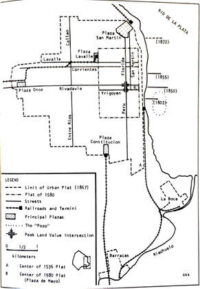
Figure 1: Pre-modern city form
|
Modern Urban Growth and the Progressist Model in Buenos Aires (1870-1900)
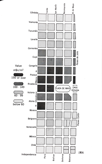
Figure 2: Plaza de Mayo and surrounding city dwelling prices.
|
The manner in which Buenos Aires formed in the latter part of the 19th century was due to three factors: The port, railroads, and the federal capital[3]. The want for expansion of trade and pushed many to advocate for the port of Madero, a port that would allow for Buenos Aires to increase the exchange of their agricultural yields for manufactured goods. The yearn to move Buenos Aires up as a political power lead to the city’s harbor being located east of the Plaza de Mayo. This transformed the Plaza de Mayo to being the main hub of commerce and wealth. The plaza, which was now known as the central city, was built on a grid consisting of 6 districts. The closer in proximity to the Plaza de Mayo, the more wealthy you had to be, as shown in figure 2. The plaza also served as the main hub for political and commercial activities. The main governmental buildings were clustered in the center city to have them in close proximity due to the fact that the buildings communicated between each other[4].
|
|
Within the architecture of the central city of Buenos Aires, in the latter part of the 19th century, Italian influences were abundant. The facade of the buildings were greatly ornamented and decorated with intricate designs. The Avenida de Mayo took influence from the grand boulevards of Paris. The architects that created these grand facades were French trained and included elements such as: grand entrances, foyers, and vestibules [5]. The ornamentation and grand design aimed to show the wealth and stature of the central city residents. This transformation of the spatial conditions of Buenos Aires during this time coincides with the “international impulse of nineteenth-century society towards material progress. The residents wished to show “the spirit, ambitions, and values of an upper class eager to parade its wealth and accomplishments and emulate the world’s most current fashions”[5].
|
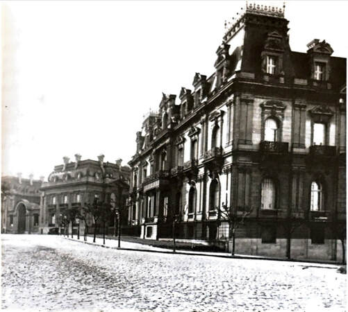
Figure 3: French-influenced architecture in Buenos Aires
|
Due to the price range of the central city, new residents would come in and spread outward from the plaza. In the outskirts of the city conventillos, which were houses where poor immigrants lived, were spread throughout. These were cramped buildings that often housed up to 30 people in one building. The conventillos were designed very regularly. There was a framework of patio-style buildings that had a single entrance on the street and an internal communal patio area. The rooms were 12x12 feet and there were no windows unless the room faced the street. However, due to the value of square footage, the communal patios began to shrink to the point where they were simply corridors. The boom of population during this time forced individuals into tenement housing in which they fit 350 persons into a building that formerly accommodated 25 individuals. These conventillos were formerly made for middle class individuals, but with densification of population many poorer individuals had no choice but to fill these dwellings [6]. Overall, there was a sharp contrast between the wealthy and the poor within this city.
|
|
 Figure 4: Parque Tres de Febrero
The idea of city planning and modernization took place in the same period when the government began to use policies in order to shape social changes. Again, this shows the relationship of political state and the formation of space. In regards to public space, politicians wanted to use the urban space to help spark social change [6]. For example, the creation of Parque Tres de Febrero, shown in orange in figure 4, was created in order to beautify Buenos Aires and help with the health of the city, since politicians believed that open spaces help to cleanse the city [7]. The density of the grid overtook the natural open space that existed before Buenos Aires, and the goal was to break the gridded pattern and provide an open space that citizens can enjoy. This theme continued not only during this period, but into the 20th century as well, as we will discuss in the "Modern Buenos Aires" tab. The Parque Tres de Febrero was added to Buenos Aires in hopes to heal the city of its ills. One problem, however, is that this grandiose space was only accessible by the wealthiest individuals of Buenos Aires due to its location to the waterfront. Rent and property value were much higher toward the water, therefore access was primarily for those who lived adjacent to the space.
|
Toward the end of the 19th century, a transformation of the space went underway. The political ruler, Dardo Rocha (1838-1921), promised to reshape the provincial capital. This brought about La Plata, a new capital that was based on French and American influence [8]. The use of a gridded plan with large diagonals to the city center can be seen within figure 5. The large avenues were largely influenced by the french boulevards. This plan was used as a way to compete with the world’s powerhouses at the time. Buenos Aires wished to incorporate the successful plans of France and America in order to become an influencer as well. This plan reveals the progressist model that Buenos Aires begins to follow during the end of the 19th century. The streets were lined with trees and uniformly gridded. The classic grid pattern found in Spanish America was revamped to align with this progressist mode [8].
|
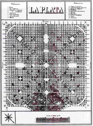
Figure 5: La Plata
|
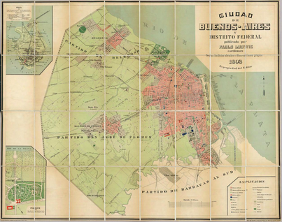
Figure 6: Buenos Aires City Plan of 1892
|
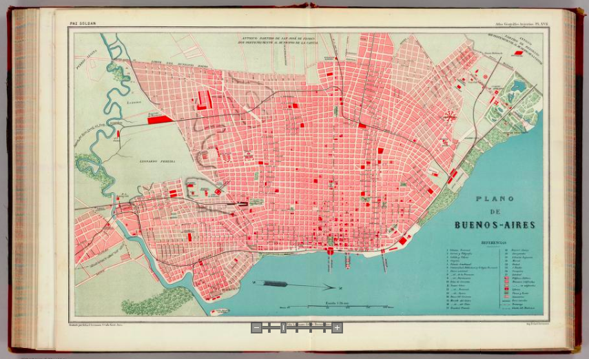
Figure 7: Buenos Aires City Plan of 1888
|
It can be seen that the plans of Buenos Aires follow a very regular pattern that was inspired by the superpowers of the planning world during the 19th century. As it can be seen within the city plans of Buenos Aires, there is a strong sense of grid toward the waterfront - which is the main focal point that the politicians wished to highlight - in order to allow for easy access to trade and commerce. As shown in Figures 6 and 7, As you stray further from the waterfront, or Rio De La Plata, the sense of grid becomes less apparent and becomes more sparse and organic[9][10]. This is due to the outward expansion from the central city, or the Plaza de Mayo.
Overall, the 19th century showcased the movement to a modern method of planning for Buenos Aires. Political initiative lead to the movement of the central city to the waterfront and the complete transformation of the city capital. This century marked a time where Buenos Aires yearned to become a political powerhouse and commercial hub; they reflected this desire by changing the layout and plan of the city. Ultimately the political initiatives lead to the policy changes that reshaped Buenos Aires during this century.
Overall, the 19th century showcased the movement to a modern method of planning for Buenos Aires. Political initiative lead to the movement of the central city to the waterfront and the complete transformation of the city capital. This century marked a time where Buenos Aires yearned to become a political powerhouse and commercial hub; they reflected this desire by changing the layout and plan of the city. Ultimately the political initiatives lead to the policy changes that reshaped Buenos Aires during this century.
References
[1] Charles S. Sargent, The Spatial Evolution of Greater Buenos Aires, Argentina, 1870-1930 (Tempe : Center for Latin American Studies, Arizona State University, 1936), http://roger.ucsd.edu/search~s/t?Spatial%20Evolution%20of%20Greater%20Buenos%20Aires%2C%20Argentina%2C%201870-1930.
[2] Mark D. Szuchman, Order, Family, and Community in Buenos Aires, 1810-1860 (Stanford, Calif: Stanford University Press, 1988).
[3] James R. Scobie, Buenos Aires : Plaza to Suburb, 1870-1910 (New York : Oxford University Press, 1974, 1974),
[4] Sargent, The Spatial Evolution of Greater Buenos Aires, Argentina, 1870-1930.
[5] Scobie, Buenos Aires : Plaza to Suburb, 1870-1910.
[6] Joel Outtes, “Disciplining Society through the City: The Genesis of City Planning in Brazil and Argentina (1894–1945),” Bulletin of Latin American Research 22, no. 2 (2003): 137–64, https://doi.org/10.1111/1470-9856.00069.
[7] Agustina Martire, “Imported and Translated Landscapes: Buenos Aires Nineteenth-Century Waterfront Parks,” Studies in the History of Gardens & Designed Landscapes 32, no. 4 (October 1, 2012): 258–76, https://doi.org/10.1080/14601176.2012.719668.
[8] Julio Angel Morosi, “La Plata: An Advanced Nineteenth Century New Town with Ancient Roots,” Planning Perspectives 18, no. 1 (January 2003): 23, https://doi.org/10.1080/0266543032000047396.
[9] Paz Soldan and Mariano Felipe, Plano de Buenos-Aires. - David Rumsey Historical Map Collection (Buenos Aires, Argentina: Feliz Lajouane), accessed February 10, 2019, https://www.davidrumsey.com/luna/servlet/detail/RUMSEY~8~1~20649~570026:Plano-de-Buenos-Aires-?sort=Pub_Date%2CPub_List_No_InitialSort&qvq=q:List_No%3D%273690.017%27%22%20;sort:Pub_Date%2CPub_List_No_InitialSort;lc:RUMSEY~8~1&mi=0&trs=1.
[10] Pablo Ludwig, Ciudad de Buenos-Aires y Distrito Federal. “City of Buenos Aires and Federal District.” (Pablo Ludwig, 1892), https://www.davidrumsey.com/luna/servlet/detail/RUMSEY~8~1~3702~340019:Ciudad-de-Buenos-Aires-y-Distrito-F?sort=pub_list_no_initialsort%2Cpub_date%2Cpub_list_no%2Cseries_no&qvq=w4s:/where%2FBuenos%2BAires%2B%252528Argentina%252529;q:buenos%20aires;sort:pub_list_no_initialsort%2Cpub_date%2Cpub_list_no%2Cseries_no;lc:RUMSEY~8~1&mi=11&trs=14.
Images
Image 1: Pre-modern City Form
Image 2: Plaza de Mayo and surrounding city dwelling prices
Image 3: French influenced architecture in Buenos Aires
Image 4: Parque Tres de Febrero
Image 5: La Plata
Image 6: Buenos Aires City plan of 1892
Image 7: Buenos Aires City plan of 1888
